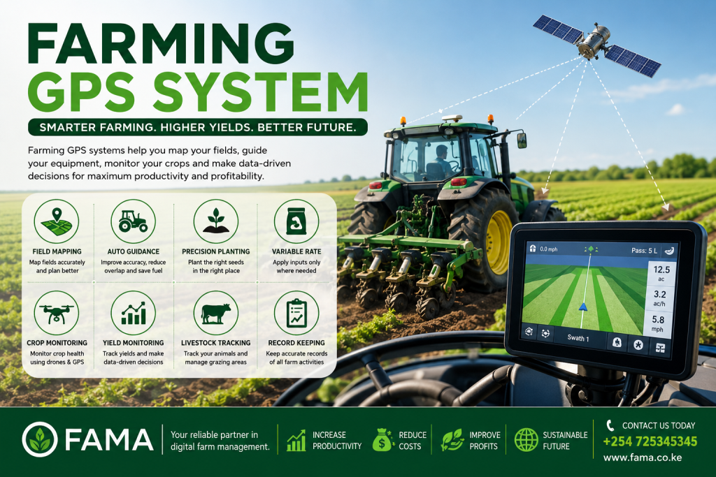
Farming GPS System: Transforming Modern Agriculture Through Precision Farming
Agriculture has evolved tremendously over the last few decades. Traditional farming methods, while effective in their time, are no longer sufficient to meet the increasing demand for food, efficient resource utilization, and sustainable farming practices. One of the most significant innovations revolutionizing agriculture today is the Farming GPS System.
A Farming GPS System enables farmers to manage their land with remarkable precision by using satellite positioning technology to guide farming operations. Whether you own a small family farm or operate thousands of acres of commercial farmland, GPS technology allows you to maximize productivity while minimizing waste.
At FAMA, we believe technology should empower every farmer. Our agricultural management platform supports modern farming by helping farmers combine GPS technology with intelligent farm management software, resulting in better planning, monitoring, and decision-making.
What is a Farming GPS System?
A Farming GPS System is a satellite-based positioning solution that helps farmers accurately determine the location of machinery, crops, livestock, field boundaries, and farming activities.
Using signals transmitted from Global Positioning System satellites, GPS devices can determine their location within a few centimeters when combined with advanced correction technologies.
Modern Farming GPS Systems are used for:
- Field mapping
- Land measurement
- Soil sampling
- Tractor guidance
- Precision planting
- Fertilizer application
- Irrigation management
- Crop scouting
- Yield monitoring
- Livestock tracking
Instead of relying on estimates, farmers receive accurate data that improves every farming decision.
Why Farming GPS Systems Matter Today
Modern agriculture faces numerous challenges including:
- Rising production costs
- Climate change
- Limited farmland
- Water shortages
- Labour shortages
- Increasing fertilizer prices
- Pest outbreaks
- Higher food demand
A Farming GPS System addresses many of these problems by ensuring every farming operation is performed with maximum efficiency.
Rather than applying fertilizer across an entire field equally, GPS allows farmers to target only areas that require treatment.
Instead of overlapping during spraying, tractors follow optimized paths.
Instead of guessing field sizes, farmers receive exact measurements.
These improvements translate directly into higher profitability.
How Does a Farming GPS System Work?
The Farming GPS System operates using satellites orbiting the Earth.
Here’s the simplified process:
1. Satellite Signals
Multiple satellites continuously transmit location signals.
2. GPS Receiver
A receiver installed on a tractor, drone, smartphone, or handheld device collects these signals.
3. Position Calculation
The receiver calculates its exact geographic position using signals from multiple satellites simultaneously.
4. Mapping Software
The GPS coordinates are displayed on digital farm maps.
5. Farm Operations
Farmers use these maps to guide machinery, monitor crops, measure land, and record farming activities.
When integrated into a farm management platform like FAMA, GPS data becomes even more powerful because every activity is stored digitally for future planning and analysis.
Components of a Farming GPS System
A complete Farming GPS System typically consists of several components.
GPS Receiver
This is the hardware that receives satellite signals.
Examples include:
- Handheld GPS units
- Smartphone GPS
- Tractor-mounted receivers
- Drone GPS modules
Display Monitor
The display provides:
- Navigation
- Field boundaries
- Tractor guidance
- Activity tracking
- Coverage maps
Guidance Controller
Advanced tractors use automated steering systems that follow GPS guidance with incredible accuracy.
This reduces overlaps and missed areas.
Farm Management Software
Software connects GPS information with:
- Farm records
- Crop management
- Financial records
- Irrigation schedules
- Labour tracking
- Inventory
This creates a complete digital farming ecosystem.
Key Features of a Farming GPS System
Accurate Field Mapping
GPS allows farmers to create accurate digital maps of their farms.
These maps include:
- Boundaries
- Roads
- Irrigation lines
- Buildings
- Crop zones
- Soil types
Digital maps eliminate confusion and improve planning.
Precision Planting
Planting seeds in perfectly straight rows improves:
- Crop spacing
- Sunlight exposure
- Nutrient availability
- Harvest efficiency
GPS-guided planting ensures uniform seed placement.
Variable Rate Application
Not every section of a field requires identical fertilizer amounts.
GPS systems combine with soil analysis to apply:
- Fertilizer
- Lime
- Herbicides
- Pesticides
only where needed.
This reduces costs while improving yields.
Tractor Navigation
Modern tractors equipped with GPS can automatically steer themselves.
Benefits include:
- Reduced driver fatigue
- Better fuel efficiency
- Faster operations
- Improved accuracy
- Lower labour costs
Yield Monitoring
During harvesting, GPS records crop yields from different field sections.
Farmers can identify:
- High-performing areas
- Poor-performing zones
- Soil problems
- Drainage issues
Future management decisions become data-driven.
Benefits of Using a Farming GPS System
Increased Productivity
GPS reduces wasted time.
Farm operations become:
- Faster
- More accurate
- Better organized
This allows farmers to accomplish more work each day.
Lower Production Costs
Reducing overlaps during:
- Spraying
- Fertilizing
- Seeding
results in significant savings.
Even a 5% reduction in input costs can substantially improve farm profitability.
Improved Crop Health
Accurate application of farm inputs prevents:
- Under-fertilization
- Over-fertilization
- Chemical burn
- Nutrient deficiencies
Healthy crops produce better yields.
Better Decision Making
GPS provides reliable farm data.
Instead of guessing, farmers make informed decisions based on:
- Historical maps
- Yield reports
- Soil information
- Weather records
Environmental Protection
Precision agriculture reduces unnecessary chemical applications.
Benefits include:
- Cleaner rivers
- Healthier soil
- Reduced pollution
- Better biodiversity
Sustainable farming becomes achievable.
Farming GPS System Applications
GPS technology can be applied throughout the farming season.
Land Preparation
Before planting, GPS helps:
- Measure fields
- Create maps
- Plan drainage
- Mark boundaries
Planting
During planting, GPS ensures:
- Straight rows
- Accurate spacing
- Reduced overlaps
Fertilizer Application
GPS guides fertilizer spreaders for uniform coverage.
Irrigation Planning
GPS assists in designing efficient irrigation systems by identifying:
- Slopes
- Water flow
- Elevation changes
Pest Monitoring
Farmers record exact locations where pests appear.
Future outbreaks can be predicted and controlled faster.
Harvesting
GPS-enabled combines record yield maps for every section of the field.
Farmers immediately identify profitable and unproductive zones.
GPS Systems for Different Types of Farming
Crop Farming
GPS supports:
- Maize farming
- Wheat farming
- Rice farming
- Sugarcane
- Coffee
- Tea
- Vegetables
Livestock Farming
GPS helps track:
- Grazing locations
- Animal movement
- Fencing
- Water sources
Livestock management becomes more efficient.
Dairy Farming
GPS improves:
- Pasture management
- Feed planning
- Grazing rotation
Horticulture
Fruit farmers use GPS to manage:
- Orchards
- Greenhouses
- Irrigation
- Fertilizer schedules
Precision Agriculture and GPS
Precision agriculture depends heavily on GPS technology.
The objective is simple:
Apply the right input…
At the right location…
At the right time…
In the right quantity.
This principle significantly improves efficiency while reducing waste.
Precision agriculture combines:
- GPS
- Drones
- Soil sensors
- Farm software
- Weather data
- Satellite imagery
- Artificial Intelligence
Together, these technologies create smart farming systems capable of increasing yields while lowering production costs.
Common GPS Equipment Used on Farms
Farmers today can choose from several GPS-enabled devices.
Popular options include:
- Handheld GPS units
- Agricultural tablets
- GPS tractors
- Auto-steering systems
- Field mapping software
- Agricultural drones
- GPS collars for livestock
- Mobile farming apps
The best solution depends on farm size, budget, and farming objectives.
Challenges of Implementing a Farming GPS System
Despite its many benefits, adopting GPS technology comes with several challenges.
Initial Investment
Purchasing GPS equipment requires upfront capital.
However, the long-term savings often outweigh the initial cost.
Training Requirements
Farmers must learn how to:
- Interpret GPS maps
- Operate GPS equipment
- Analyze collected data
Training improves adoption success.
Internet Connectivity
Some cloud-based farming platforms require internet access.
Fortunately, many GPS devices continue functioning offline and synchronize data once connectivity is restored.
Equipment Compatibility
Older tractors may require additional hardware to integrate with GPS guidance systems.
Careful planning ensures compatibility before investment.
Advanced Uses of a Farming GPS System
As agriculture becomes increasingly data-driven, a Farming GPS System is no longer limited to navigation. Modern GPS technology integrates with farm management software, drones, sensors, weather information, and machinery to create a connected farming ecosystem. This enables farmers to make faster decisions based on accurate field data rather than assumptions.
Integrating GPS with Farm Management Software
A GPS device becomes even more valuable when connected to a comprehensive farm management platform like FAMA. Instead of storing location data separately, every farming activity can be linked to specific fields and production records.
For example, farmers can:
- Record planting dates for each field.
- Track fertilizer application by location.
- Monitor pesticide spraying history.
- Assign workers to specific plots.
- Schedule irrigation based on mapped zones.
- Compare production across multiple seasons.
- Generate reports for farm performance.
Having all farm information in one centralized system improves organization and simplifies daily operations.
Farming GPS System and Smart Irrigation
Water is one of the most valuable resources in agriculture. Efficient irrigation is essential for maximizing yields while conserving water.
A Farming GPS System helps farmers design irrigation layouts based on field topography, elevation, and soil characteristics. Combined with moisture sensors, GPS allows irrigation systems to deliver water precisely where it is needed.
Benefits include:
- Reduced water wastage
- Improved crop growth
- Lower pumping costs
- Better drought management
- Uniform crop development
This approach is particularly beneficial in areas where rainfall is unpredictable.
Soil Mapping Using GPS Technology
Every farm contains variations in soil fertility, pH, drainage, and nutrient availability. Treating the entire farm as though it has identical soil conditions often leads to unnecessary costs and uneven crop performance.
GPS makes detailed soil mapping possible.
Farmers can collect soil samples from precise locations and create digital soil maps showing:
- Soil pH
- Organic matter
- Nitrogen levels
- Phosphorus content
- Potassium levels
- Soil texture
- Moisture retention
These maps guide fertilizer application, helping farmers improve soil health while reducing unnecessary input costs.
GPS and Fertilizer Management
Fertilizer represents a significant portion of farming expenses. Applying too much wastes money and may damage crops, while applying too little can reduce yields.
A Farming GPS System enables precision fertilizer application by targeting specific areas according to crop requirements and soil analysis.
Advantages include:
- Lower fertilizer costs
- Better nutrient efficiency
- Increased crop yields
- Reduced environmental pollution
- Improved profitability
Variable-rate fertilizer application has become one of the most valuable uses of GPS technology in commercial agriculture.
GPS for Crop Monitoring
Farmers no longer need to inspect every acre manually.
GPS technology helps identify specific field locations requiring attention.
During crop scouting, farmers can mark areas experiencing:
- Pest infestations
- Disease outbreaks
- Poor germination
- Waterlogging
- Nutrient deficiencies
- Weed growth
These locations are saved digitally, making follow-up inspections easier and ensuring problems are addressed before they spread.
Drone Technology and Farming GPS Systems
Agricultural drones rely heavily on GPS for accurate flight paths and data collection.
When paired with GPS technology, drones can:
- Capture high-resolution aerial images.
- Monitor crop health.
- Detect irrigation issues.
- Estimate plant populations.
- Identify disease outbreaks.
- Generate vegetation maps.
- Monitor crop growth throughout the season.
This provides farmers with valuable insights without spending hours walking through fields.
GPS for Livestock Management
Livestock farmers also benefit from GPS technology.
GPS tracking collars can monitor animal movement across grazing fields, allowing farmers to:
- Locate animals quickly.
- Prevent theft.
- Monitor grazing patterns.
- Rotate pastures effectively.
- Improve pasture utilization.
- Detect unusual animal behavior.
This enhances livestock management while reducing labor requirements.
GPS in Farm Machinery
Modern agricultural machinery is increasingly equipped with GPS systems.
Examples include:
- Tractors
- Seed drills
- Planters
- Fertilizer spreaders
- Sprayers
- Harvesters
GPS guidance helps operators maintain straight paths, avoid overlaps, and reduce missed areas, improving efficiency and reducing fuel consumption.
Reducing Fuel Consumption with GPS
Fuel expenses can account for a substantial portion of farm operating costs.
A Farming GPS System reduces unnecessary fuel use by:
- Optimizing travel routes
- Eliminating repeated passes
- Improving field coverage
- Reducing idle time
- Enhancing machinery efficiency
Over an entire season, these improvements can translate into significant cost savings.
Improving Farm Safety
GPS contributes to safer farming operations.
It can help:
- Locate machinery quickly.
- Track workers in large farms.
- Identify hazardous areas.
- Guide equipment during poor visibility.
- Improve emergency response.
This creates a safer working environment for farm employees.
Record Keeping with GPS
Modern farming requires detailed records for financial management, certifications, insurance, and regulatory compliance.
GPS simplifies record keeping by automatically recording:
- Dates
- Locations
- Field activities
- Machinery usage
- Operator information
- Input application records
Digital records are easier to retrieve and analyze than paper files.
Choosing the Right Farming GPS System
When selecting a Farming GPS System, farmers should consider:
- Farm size
- Crop type
- Budget
- Desired accuracy
- Equipment compatibility
- Ease of use
- Software integration
- Technical support
- Future scalability
Investing in a solution that can grow with your farming operations provides better long-term value.
Why Kenyan Farmers Are Adopting GPS Technology
Across Kenya, farmers are increasingly embracing precision agriculture to improve productivity and reduce production costs.
GPS technology is helping farmers:
- Manage larger farms efficiently.
- Improve fertilizer use.
- Reduce labor costs.
- Increase yields.
- Enhance record keeping.
- Support sustainable farming practices.
As access to digital tools improves, GPS adoption is expected to continue growing across both smallholder and commercial farms.
Future Trends in Farming GPS Systems
The future of agricultural GPS technology is promising.
Emerging innovations include:
- Artificial Intelligence-assisted farm recommendations.
- Autonomous tractors.
- Real-time machinery coordination.
- Satellite crop monitoring.
- Internet of Things (IoT) farm sensors.
- Automated irrigation systems.
- Predictive yield analytics.
- Cloud-based farm management platforms.
These technologies will make farming more efficient, resilient, and profitable.
Frequently Asked Questions (FAQs)
What is a Farming GPS System?
A Farming GPS System uses satellite positioning technology to accurately locate machinery, fields, crops, and farm activities, enabling precision agriculture.
Is GPS suitable for small farms?
Yes. Small-scale farmers can benefit from GPS-enabled smartphones, handheld GPS devices, and affordable farm management software to improve planning and record keeping.
Does GPS work without an internet connection?
Yes. GPS receives signals directly from satellites and does not require internet access to determine location. Some cloud features may synchronize when internet connectivity becomes available.
Can GPS improve crop yields?
Yes. By improving planting accuracy, fertilizer placement, irrigation planning, and field monitoring, GPS contributes to healthier crops and better yields.
Is GPS useful for livestock farming?
Absolutely. GPS can track grazing patterns, monitor animal movement, improve pasture management, and help locate livestock quickly.
Can GPS reduce farming costs?
Yes. Precision guidance minimizes overlaps during planting, spraying, and fertilizing, reducing fuel, labor, seed, fertilizer, and chemical expenses.
Why Choose FAMA for Digital Farm Management?
Technology is transforming agriculture, and farmers need solutions that are practical, reliable, and easy to use. FAMA is designed to help farmers embrace digital farming by bringing together farm records, crop planning, task management, inventory, reporting, and operational insights in one place.
Whether you manage a small family farm or a large commercial enterprise, integrating a Farming GPS System with FAMA helps improve efficiency, streamline farm operations, and support better decision-making throughout the production cycle.
Building a Data-Driven Farming Culture
Beyond the technology itself, one of the greatest advantages of adopting modern farming tools is the ability to build a culture of continuous improvement. Every season presents an opportunity to learn from previous experiences, compare performance, and make better decisions for the future. By collecting reliable information throughout the production cycle, farmers can identify patterns that would otherwise go unnoticed.
Historical records allow farm managers to compare yields across different seasons, evaluate the performance of various crop varieties, and determine which farming practices consistently produce the best results. This information also supports budgeting, resource planning, and risk management by providing accurate data instead of estimates.
Digital records improve communication among farm owners, managers, employees, and agricultural advisors. Everyone involved can work from the same information, reducing misunderstandings and ensuring that farm activities are completed according to schedule. As operations expand, organized documentation becomes increasingly important for maintaining efficiency and accountability.
In addition, reliable farm data can support access to financing, insurance, and certification programs that require accurate production records. Well-documented farming operations demonstrate professionalism and make it easier to plan future investments. By embracing technology and maintaining consistent records, farmers create a stronger foundation for sustainable growth, improved profitability, and long-term success in an increasingly competitive agricultural industry.
Conclusion
A Farming GPS System has become one of the most valuable technologies in modern agriculture. From field mapping and precision planting to fertilizer management, irrigation planning, livestock tracking, and yield monitoring, GPS enables farmers to make informed decisions that increase productivity while reducing costs.
As precision agriculture continues to evolve, GPS technology will remain at the center of smarter, more sustainable farming. Farmers who invest in digital tools today are positioning themselves for greater efficiency, improved profitability, and long-term resilience.
If you’re ready to modernize your farm operations with intelligent farm management solutions, FAMA is here to help.
Contact FAMA Today
📞 Phone: +254 725345345
Discover how digital farm management and GPS-enabled farming can help you optimize operations, improve productivity, and build a more profitable agricultural business.